The Annapurna Circuit Trek from Pokhara is widely regarded as one of the greatest trekking adventures on earth. This legendary route circles the entire Annapurna Massif, crossing five distinct climate zones, summiting the formidable Thorong La Pass at 5,416 m (17,769 ft), and weaving through Gurung villages, Buddhist monasteries, subtropical forests, and high-altitude desert plateau.
Starting this journey from Pokhara, Nepal’s adventure capital, makes both logistical and experiential sense, with shorter transfers, easy gear access, and a full loop that returns you to the same lakeside city where your adventure began.
At Hi Nepal Travels and Treks, we have guided trekkers from every corner of the world along this route. This guide is the most comprehensive resource you’ll find, covering the detailed day-by-day itinerary, a visual route map and elevation profile, season guide, permits, costs, a packing list, and expert tips refined over years on the trail.
Quick Facts: Annapurna Circuit Trek from Pokhara
Why Start the Annapurna Circuit Trek from Pokhara?
Most international trekkers land in Kathmandu, but Pokhara is the superior gateway for the Annapurna Circuit for several compelling reasons.
Faster trailhead access: From Pokhara, it’s just a 2–3 hour drive to Besisahar, the official circuit start. Kathmandu-based trekkers face a 6–7 hour drive or an additional flight, adding a full day to their journey.
A true circular adventure: Starting and finishing in Pokhara means you complete a genuine geographic loop, ascending the Marsyangdi Valley (east), crossing Thorong La, descending through the Kali Gandaki (west), and returning via Ghorepani and Poon Hill. The satisfying arc of this journey is unique to the Pokhara-based approach.
Perfect pre-trek base: Pokhara’s Lakeside district is ideal for preparation, gear shops, pharmacies stocking Diamox, the NTB permit office, good restaurants, and comfortable hotels are all within walking distance. The city at 822 m also provides gentle pre-acclimatization.
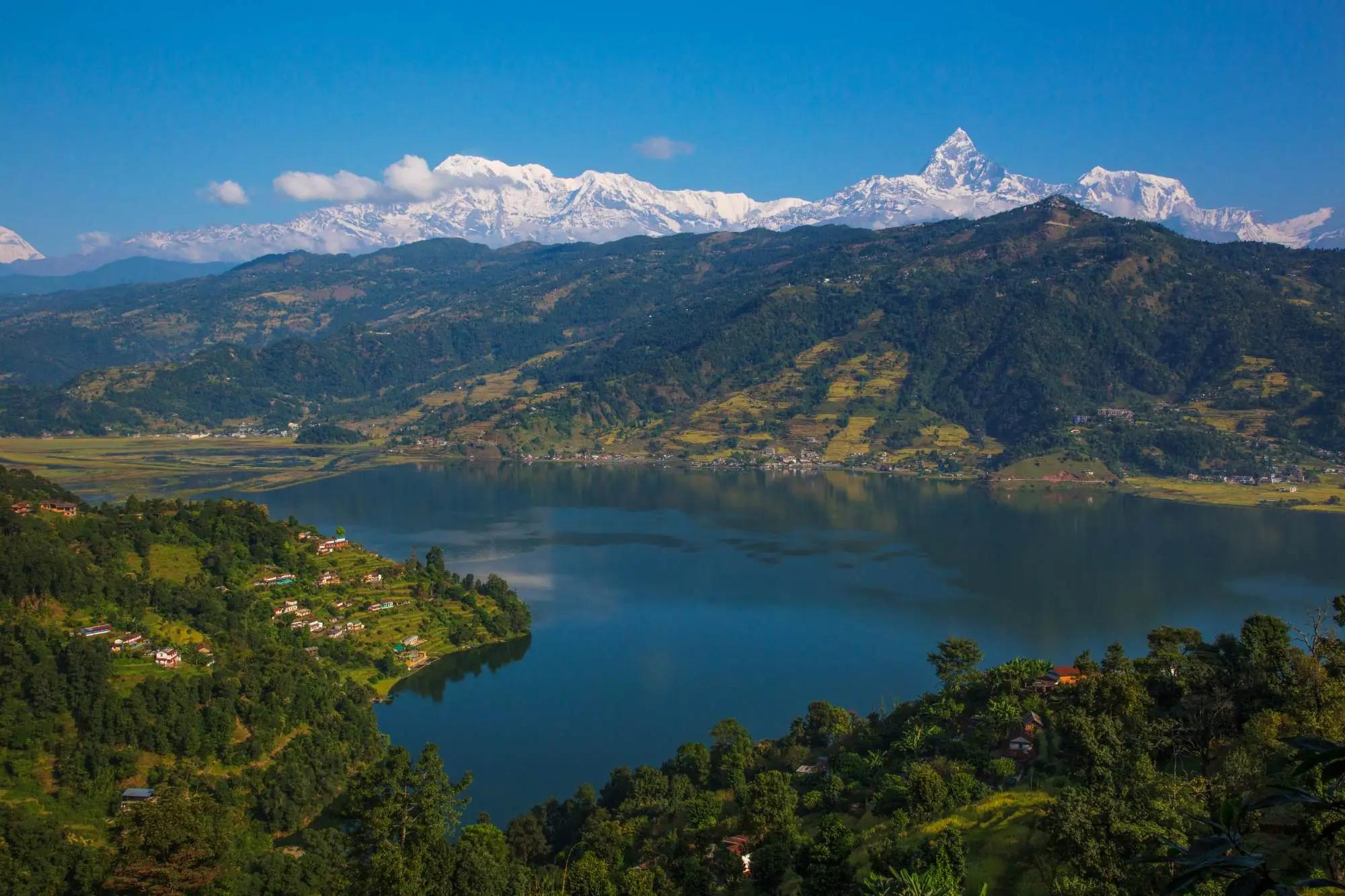
A celebration finish: After 13 days on the trail, returning to Pokhara’s lakeside cafés, hot showers, and the iconic reflection of Machhapuchhre (Fishtail) in Phewa Lake is the perfect reward for your Annapurna achievement.
Top Highlights of the Annapurna Circuit Trek from Pokhara
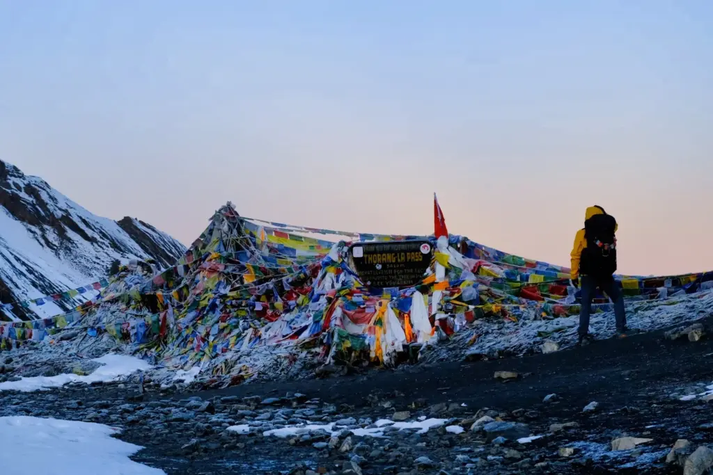
Thorong La Pass (5,416 m): The defining moment of the trek, a pre-dawn crossing with a 360° Himalayan panorama that stays with you for a lifetime.
Manang Valley and Ice Lake: High-altitude Tibetan culture, dramatic glaciers, and an acclimatization hike to one of the circuit’s finest viewpoints at 4,600 m.
Tilicho Lake (optional, 4,949 m): A 2-day side trip to one of the highest and most beautiful lakes on earth, a glacial turquoise jewel in a savage high-altitude landscape.
Muktinath Temple: Sacred to both Hindus and Buddhists, with 108 holy water spouts and an eternal flame, a profound spiritual stop after the hardest day of the trek.
Marpha and the Apple Brandy: Nepal’s “Apple Capital” produces surprisingly excellent local wine, cider, and brandy in a stunning whitewashed Thakali village.
Kali Gandaki Gorge: The world’s deepest gorge by some measurements, a wind-swept corridor between Dhaulagiri and Annapurna I with extraordinary geological drama.
Poon Hill Sunrise: The most celebrated mountain sunrise viewpoint in the Annapurna region, twelve Himalayan peaks above 6,000 m illuminated simultaneously at dawn.
Ghandruk Village: The most photogenic traditional Gurung village in Nepal, with stone houses, a cultural museum, and sweeping Annapurna South views.
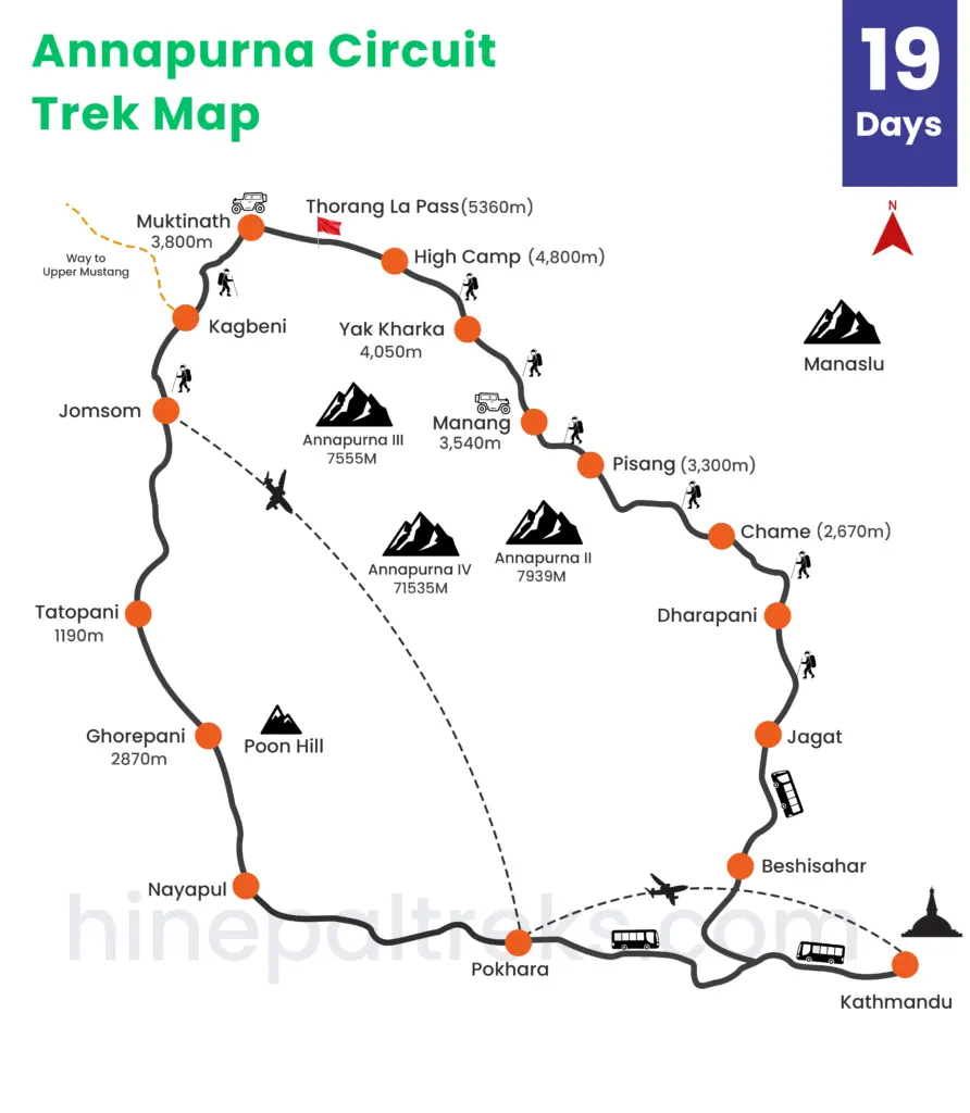
Route Overview: Annapurna Circuit from Pokhara
The Annapurna Circuit circumnavigates the Annapurna Massif through two great river valleys, ascending the Marsyangdi Valley on the east and descending through the Kali Gandaki Gorge on the west.
Ascending Route (Eastern — Marsyangdi Valley)
Pokhara → Besisahar → Bhulbhule → Bahundanda → Chamje → Dharapani → Bagarchhap → Chame → Pisang → Manang → Ledar → Thorong Phedi → High Camp → Thorong La Pass (5,416 m) → Muktinath
Descending Route (Western — Kali Gandaki Gorge)
Muktinath → Kagbeni → Marpha → Jomsom → Ghasa → Tatopani → Ghorepani → Poon Hill (3,210 m) → Tadapani → Ghandruk → Nayapul → Pokhara
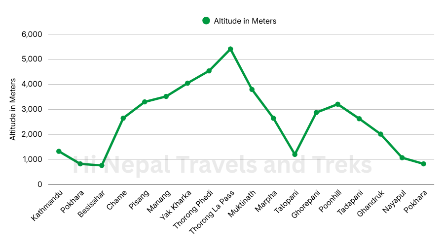
Annapurna Circuit Trek Route Map & Elevation Profile
The map below illustrates the complete Annapurna Circuit route from Pokhara.
Detailed Day-by-Day Itinerary: Annapurna Circuit Trek from Pokhara (14 Days)
Below is Hi Nepal Travels and Treks‘ optimized 14-day itinerary, refined through hundreds of completed circuits. Each day card includes the route, altitude, duration, a detailed description of what to expect on the trail, and a guide tip based on firsthand experience.
Day 1: Pokhara → Besisahar (Drive)
Stay: Besisahar
Altitude: 760 m
Drive: 2–3 hours (~72 km)
Meals: Dinner included
Highlights: Scenic Marsyangdi River highway, Final permit and gear check, Besisahar market exploration, First dal bhat dinner
Departure from Pokhara by private jeep at 7:00 AM, heading north along the Prithvi Highway following the Marsyangdi River through fertile midhill terrain. The drive passes through Damauli and Khudi before arriving at Besisahar (760 m), administrative headquarters of Lamjung District and the official start of the Annapurna Circuit trekking route.
On arrival, your Hi Nepal guide will complete permit checks, brief you on trek protocols, pack your duffel bags for the porter, and distribute any rental gear. Spend the afternoon exploring Besisahar’s local market. The evening dal bhat dinner, lentil soup, rice, vegetable curry, and pickles, is your first authentic Himalayan trekking meal. Early bedtime is strongly advised: trekking begins tomorrow.
Day 2: Besisahar → Bahundanda
Stay: Banhundanda
Altitude: 1,310 m
Trek: 5–6 hours (~14 km) | Moderate
Meals: Breakfast, Lunch, Dinner
Highlights: Multiple long suspension bridges, Subtropical bird life, Gurung and Magar village culture, First distant snow-peak glimpses
Your first real day on foot. The trail follows the eastern bank of the Marsyangdi River through a gorgeous sequence of rice paddies, millet fields, suspension bridge crossings, and Gurung and Magar villages. The subtropical jungle along the lower trail is rich with bird life — watch for laughing thrushes, bulbuls, and if you are lucky, a Himalayan monal pheasant (Nepal’s national bird).
Ngadi (900 m) makes a natural mid-morning tea stop. The trail then climbs more steeply through terraced farmland to Bahundanda (“Hill of Brahmins”), a ridge-perched village at 1,310 m with sweeping valley views and the first faint outlines of snow-capped peaks to the north. The evening here is quiet and local, this is not a heavy tourist stop, and that is its charm.
Day 3: Bahundanda → Chame
Stay: Chame
Altitude: 2,650 m
Trek:6–7 hours (~22 km) | Moderate-Steep
Meals: Breakfast, Lunch, Dinner
Highlights: Dramatic Marsyangdi gorge, Flat meadow of Tal — ancient glacial lake bed, Tibetan village architecture begins, Last reliable ATM, withdraw cash, Hot springs in Chame
A demanding day with over 1,400 m of altitude gain through increasingly dramatic scenery. The gorge narrows at Chamje, where the Marsyangdi crashes through a tight rock corridor. Then, almost suddenly, the valley opens into the wide flat meadow of Tal, an ancient glacial lake bed now grazed by water buffalo and dotted with small farms.
After Tal, the climb resumes through Dharapani and on to Bagarchhap, where the landscape shifts distinctively: flat-roofed stone houses, carved mani walls, prayer flags, and the smell of juniper incense announce the beginning of the Tibetan cultural zone.
Chame, the district capital of Manang, has ATMs, well-stocked bakeries, a police checkpoint, hot springs, and the best teahouse accommodation since Besisahar. This is your last reliable ATM until Jomsom on the far side of the pass, withdraw enough for 8–10 days.
Day 4: Chame → Upper Pisang
Stay: Upper Pisang
Altitude: 3,300 m
Trek: 5–6 hours (~16 km) | Moderate
Meals: Breakfast, Lunch, Dinner
Highlights: Spectacular curved cliff face, Upper Pisang monastery at sunset, Annapurna II (7,937 m) close-up views, Gentle acclimatization afternoon hike
Leaving Chame, the circuit immediately delivers one of its most memorable moments: a sheer curved rock face over 1,500 m high, streaked with waterfalls and draped in pine forest. There is nowhere else on the circuit quite like this wall of stone. The trail passes through Bhratang (known for apple orchards and a small local distillery) before reaching the Pisang fork.
We take the higher Upper Pisang route, not the lower road, for good reason. Upper Pisang is a medieval Tibetan-style village at 3,300 m with a dramatic monastery (gompa) on the cliff above the rooftops and a direct, unobstructed view of Annapurna II (7,937 m) that stops trekkers cold. An afternoon walk up to the gompa provides gentle acclimatization and extraordinary photography. Lower Pisang, by contrast, is a collection of new guesthouses along a road, completely lacking the character of its upper counterpart.
Day 5: Pisang → Manang
Stay: Manang
Altitude: 3,519 m
Trek: 5–6 hours (~18 km) | Moderate
Meals: Breakfast, Lunch, Dinner
Highlights: Full Annapurna panorama: Annapurna III, IV, Gangapurna, Gangapurna Glacier and glacial lake, HRA altitude lecture 3 PM — attend without exception, Manang bakeries and restaurants, Last reliable WiFi and phone coverage
One of the most scenically magnificent days of the circuit. The trail passes through Hongde (small airstrip, emergency evacuation point), Bhraka, and Ngawal, each village demonstrating the flat-roofed stone architecture, prayer flags, and chortens of the Annapurna high country. From Ngawal, a higher trail option reveals the Gangapurna Glacier and the achingly beautiful Gangapurna Lake.
Manang village at 3,519 m is the social and logistical hub of the circuit. Expect bakeries selling apple pie and cinnamon rolls, restaurants offering pizza and pasta, WiFi cafés, a currency exchange, and the critically important Himalayan Rescue Association (HRA) altitude clinic, which runs free altitude medicine lectures every afternoon at 3:00 PM. Attending this lecture is not optional — it provides information that has saved lives on this route.
Day 6: Manang — Acclimatization Day
Stay: Manang
Altitude: 3,519 m/ 4,000–4,600 m day hike
Trek: 3–5 hrs optional hike | Rest day
Meals: Breakfast, Lunch, Dinner
Highlights: Ice Lake hike to 4,600 m – best acclimatization option, Bhojo Gompa monastery visit, HRA lecture if missed Day 5, Hydrate 3–4 liters | carbohydrate-heavy dinner, Set alarm for 3 AM
This day is non-negotiable and cannot be safely removed from the itinerary. The science is clear: the Himalayan Rescue Association’s own data shows that trekkers who skip the Manang acclimatization day have significantly higher rates of AMS and evacuation on the Thorong La crossing. The one-day investment here saves lives and trek success rates dramatically.
The strategy is climb high, sleep low: we ascend to higher elevation during the day, then return to Manang to sleep. Three options based on fitness and altitude response:
Option A – Ice Lake (Kicho Tal, 4,600 m): A steep but achievable 3–4 hour ascent to a spectacular glacial lake with 360° panoramic views of the entire Annapurna Circuit ahead and behind you. This is the best acclimatization hike on the circuit. I strongly recommend it for all fit trekkers.
Option B – Gangapurna Lake Viewpoint (~3,900 m): A gentler 2-hour walk for those feeling altitude effects more acutely. Turquoise glacial lake framed by the Gangapurna Glacier above.
Option C – Bhojo Gompa: A relaxed 1.5-hour cultural walk to the ancient monastery above Manang, with prayer rooms, butter lamps, and resident monks.
Afternoon: complete rest, hydrate 3–4 liters minimum, attend the HRA lecture if you missed yesterday, eat well (carbohydrate-heavy meals are best at altitude), and lay out tomorrow’s gear. Set alarm for 3:00 AM.
Day 7: Manang → High Camp
Stay: High Camp
Altitude: 4,925 m
Trek: ~8 km | 3–4 hours | Steep
Meals: Breakfast, Lunch, Dinner
Highlights: High Camp 4,925 m – tactical advantage for pass day, SpO2 monitoring by guide, Gear check – lay out all layers for 3 AM departure, Early bedtime essential
A critical, short day. The trail crosses the Jarsang Khola river and climbs through Ledar (4,200 m) to Thorong Phedi (4,450 m – “Base of Thorong” in Nepali), where teahouses are crowded with anxious trekkers. Many groups stop at Phedi. We do not. We push on an additional 1.5 hours to High Camp (4,925 m).
Staying at High Camp rather than Phedi is one of the most important tactical decisions on the entire circuit. By sleeping higher, you reduce Day 8’s altitude gain by nearly 500 m, saving 1.5 to 2 hours of extreme-effort climbing at dawn. Trekkers who stay at Phedi are already at a disadvantage before pass day begins.
The High Camp teahouses are basic but warm, blankets, hot tea, and basic meals are available. Arrive, rest immediately, eat lightly, hydrate, and sleep. Lay out every single piece of cold-weather clothing and every piece of gear you will need before the lights go out.
Day 8: High Camp → Thorong La Pass → Muktinath (Summit Day)
Stay: Muktinath / Ranipauwa
Summit: 5,416 m / 17,769 ft
Trek: ~17 km | 7–9 hours | Most demanding
Meals: All meals included
Highlights: Pre-dawn start by headlamp – 3:00–4:00 AM, Thorong La Pass 5,416 m – 360° Himalayan panorama, 1,600 m descent – trekking poles absolutely mandatory, Muktinath Temple
Alarm at 3:00 AM. Light breakfast, porridge and tea only, nothing heavy. Layer up completely: base layer, fleece, down jacket, hardshell, balaclava, warm hat, gloves. Trekking poles out. Headlamp on. The pre-dawn ascent begins.
The path from High Camp climbs approximately 500 m over 4 km of rocky, switchbacking ridgeline under a sky thick with stars at 5,000 m above sea level. The silence is total except for wind, footsteps, and breathing. Take short, deliberate steps. Breathe rhythmically. Do not rush. Rushing at this altitude causes hypoxia faster than altitude itself.
At the Thorong La Pass (5,416 m), a forest of prayer flags and a stone cairn mark the summit. The panorama, on a clear day, is staggering: the full Annapurna range curving to the south, Dhaulagiri massive and white to the west, the Tibetan plateau stretching north, and the entire circuit route visible as a single coherent landscape. Most trekkers stand here quietly, or cry, or both. After months of planning and 8 days of walking, this is the moment.
The descent to Muktinath (3,800 m) takes 3–4 hours on steep, loose-gravel trail that drops 1,600 m. Trekking poles are mandatory. Take your time on the descent, more knee injuries happen here than anywhere else on the circuit. At the bottom, Muktinath Temple, one of the holiest sites in both Hinduism and Buddhism, with 108 water spouts and an eternal natural flame, provides a profound spiritual end to the hardest day of the trek.
Day 9: Muktinath → Marpha
Stay: Marpha
Altitude: 2,670 m
Trek: ~22 km | 4–5 hours | Easy-Moderate
Meals: All meals included
Highlights: Mustang desert landscape, Kagbeni medieval village, Jomsom airport – emergency exit, Marpha apple brandy tasting
A welcome descent into the extraordinary rain-shadow landscape of the Mustang region. This is high-altitude desert, treeless, wind-carved, and dramatically unlike the lush eastern valley. Fierce afternoon thermal winds (locally called the “Mustang wind”) blow south through the gorge from 11 AM onward. Depart Muktinath by 7:30 AM to arrive in Marpha before the worst of the wind.
The trail passes through Kagbeni (2,810 m), a medieval walled village with red-mud houses, narrow alleyways, and a dzong (fortress) marking the boundary of restricted Upper Mustang. Continue through Jomsom (2,720 m, with a domestic airport for emergency evacuations) to Marpha, Nepal’s “Apple Capital,” a stunning whitewashed Thakali village famous for its apple brandy, apple pie, and warm wood-stove teahouses.
Day 10: Marpha → Tatopani
Stay: Tatopani
Altitude: 1,200 m
Trek: ~24 km | 5–6 hours | Moderate descent
Meals: All meals included
Highlights: Kali Gandaki Gorge – world’s deepest, Return of subtropical forest, Tatopani natural hot springs, Celebratory evening in the warmth
A long but rewarding descent through the Kali Gandaki Gorge, the world’s deepest gorge, flanked by Dhaulagiri (8,167 m) to the west and the Annapurna massif to the east. The path drops through Ghasa (2,010 m), where subtropical vegetation dramatically returns, dense forest, ferns, waterfalls, and warm air replacing the arid desert above.
Tatopani (literally “Hot Water” in Nepali) is famous for its natural hot spring pools fed by geothermal springs at 35–45°C. Arriving in Tatopani and slipping into a hot spring after 10 days of trekking, with the gorge walls towering above you and the Kali Gandaki rushing below, is one of the most satisfying experiences on the entire circuit. The celebratory cold beer at sunset is equally non-negotiable.
Day 11: Tatopani → Ghorepani
Stay: Ghorepani
Altitude: 2,874 m
Trek: ~14 km | 6–7 hours | Steep ascent
Meals: All meals included
Highlights: Rhododendron forest in bloom (March–April), Dense oak and magnolia forest, Ghorepani teahouses, best facilities since Manang, Set alarm for 4 AM
A significant re-ascent, climbing nearly 1,700 m from the warmth of Tatopani back into cool mountain air through a beautiful forest of rhododendron, oak, and magnolia. In March and April, this forest becomes one of the most spectacular natural displays in Nepal: crimson, pink, and white rhododendron blooms canopy the trail for most of the ascent to Ghorepani.
Ghorepani (2,874 m) is a busy, welcoming trekking hub at the junction of the Annapurna Circuit and the shorter Ghorepani-Poon Hill circuit. The teahouses here are some of the best-equipped on the trail. Set your alarm tonight: the reward for this hard day comes at 4:00 AM tomorrow.
Day 12: Ghorepani → Poon Hill → Tadapani
Stay: Tadapani
Altitude: Poon Hill 3,210 m | Tadapani 2,630 m
Trek: ~16 km | 6 hours | Moderate
Meals: Breakfast, Lunch, Dinner
Highlights: Poon Hill sunrise – 12+ peaks simultaneously, Best photography opportunity of the entire trek, Peaceful rhododendron forest to Tadapani, Continuous Annapurna South views
4:00 AM. The path climbs 45 minutes through cold, dark rhododendron forest to the summit of Poon Hill (3,210 m), where a stone observation tower stands on the ridge crest. As the sky shifts from darkness to pale rose to burning gold, a panorama of 12+ Himalayan peaks unfolds simultaneously: Dhaulagiri, Annapurna South, Hiunchuli, Machhapuchhre (Fishtail), Annapurna I, II, III, IV, Gangapurna, all above 6,000 m, all glowing in the first light. This is one of the most photographed mountain sunrises on earth, and it fully deserves that reputation.
Descend to Ghorepani for breakfast, then continue through beautiful forest to Tadapani with continuous views of Annapurna South. The forest walk is peaceful and quiet after the circuit’s higher sections.
Day 13: Tadapani → Ghandruk → Nayapul → Pokhara
Stay: Pokhara
Altitude: 822 m
Trek + Drive: ~14 km | 4–5 hrs + 1.5 hrs drive
Meals: Breakfast, Lunch
Highlights: Ghandruk – most beautiful Gurung village in Nepal, Gurung Culture Museum, Return to Pokhara – circuit complete, Celebratory lakeside dinner
The final morning on the trail descends through Ghandruk (1,940 m). Slate-roofed stone houses step down the hillside in terraces, Annapurna South and Machhapuchhre frame the skyline to the north, and the Gurung culture that has shaped this region for centuries is preserved and proudly visible. Visit the Gurung Museum, have a final tea at a Ghandruk guesthouse, and take your time.
The trail drops to the Modi Khola River and crosses to Nayapul, where your Hi Nepal jeep waits. The 1.5-hour drive returns you to Pokhara and Phewa Lake. Check in, shower, change, and celebrate tonight on Lakeside, you have just completed one of the world’s great trekking routes.
Day 14: Pokhara – Rest, Sightseeing or Departure
Stay: Pokhara or fly onward
Altitude: 822 m
Activity: Leisure day
Highlights: Phewa Lake rowboat and Barahi Temple, Optional paragliding over Pokhara, International Mountain Museum, Onward travel assistance
Your final day is entirely yours. Rowboat on Phewa Lake to the Barahi Temple island. Paragliding with a bird’s-eye view of the Annapurnas. The International Mountain Museum. Seti Gorge walk. Or simply a café table on Lakeside, coffee, and the view of Machhapuchhre. Onward flights to Kathmandu or extensions to Chitwan National Park, Lumbini, or Upper Mustang are easily arranged. Hi Nepal’s team will assist with any logistics.
Thorong La Pass: What to Expect
Verified fact (Nepal Tourism Board, 2024):
Thorong La Pass at 5,416 m / 17,769 ft is one of the highest trekking passes in the world. It is open to trekkers without technical climbing equipment for approximately 9–10 months per year, typically closing only during extreme winter snowfall in January–February.
Start time. Departure from High Camp between 3:00–5:00 AM. Afternoon winds on the pass can exceed 60 km/h and create dangerous wind-chill conditions. The earlier you cross, the safer. Most trekkers summit between 8:00 and 11:00 AM.
Physical demand. Approximately 500 m of altitude gain over 4 km at over 5,000 m above sea level. At this altitude, your blood oxygen saturation (SpO2) may be 70–80%, your body is working significantly harder for the same effort that would be easy at sea level. Slow, short steps are the only sustainable technique.
Weather conditions. Even in October, the pass can have fresh snow and sub-zero wind chill. A full winter clothing system, down jacket, hardshell, balaclava, warm gloves, is non-negotiable. Do not leave High Camp without all of these on your body.
The descent. The 1,600 m descent to Muktinath is technically easier than the ascent but significantly harder on the knees, loose gravel on steep trail after hours of exertion. Trekking poles are essential. Take time, protect your joints.
Difficulty Level of Annapurna Circuit Trek
The Annapurna Circuit Trek from Pokhara is rated Moderate to Challenging. No technical mountaineering skills, ropes, or crampons are required. What is required: the ability to trek 5–9 hours daily on uneven terrain for 12–13 consecutive days, comfort at altitudes above 4,000 m, and the mental fortitude for a pre-dawn high-altitude pass crossing.
Prior multi-day trekking experience is beneficial but not mandatory for fit individuals who have trained seriously. Begin a structured training programme at least 8–10 weeks before departure: weekly long hikes (4+ hours), stair climbing, and cardio conditioning. Hi Nepal’s guides set a pace calibrated to each group’s fitness, and we have successfully guided first-time trekkers to the summit every season.
Best Season for the Annapurna Circuit Trek from Pokhara
Spring: March – May
Rhododendron forests in full bloom. Clear mornings, mild temperatures (5–20°C on trail). April and May are optimal. Thorong La reliably open and snow-free.
Autumn: September – November
Post-monsoon crystal clarity with the sharpest mountain views of the year. October is peak season globally. November is quieter and colder. Both are excellent.
Winter (December – February)
Thorong La may receive heavy snowfall and temporarily close. Possible for experienced winter trekkers in December and early March, but daytime temperatures at altitude drop to -10°C and below. All lower sections (Ghorepani, Poon Hill, Marsyangdi Valley) remain accessible.
Monsoon (June – August)
Heavy rainfall, leeches, landslide risk, and poor visibility characterize the monsoon season on lower sections. However, the Manang and Mustang valleys (above 3,000 m, in the Annapurna rain shadow) remain relatively dry, a condensed high-altitude itinerary is possible for experienced trekkers who accept the conditions.
Permits Required for Annapurma Circuit Trek
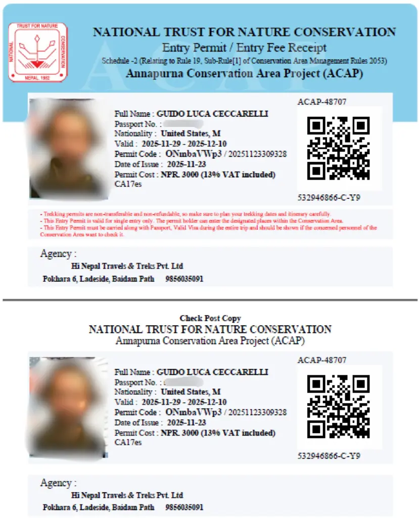
Official source:
Nepal Tourism Board (NTB) and Trekkers’ Association of Nepal (TAAN). Permit fees below verified at NTB Pokhara regional office, March 2026.
| Permit | Issuing Authority | Cost (2025) | Where to Obtain |
|---|---|---|---|
| ACAP Permit — Annapurna Conservation Area Project | National Trust for Nature Conservation (NTNC) | NPR 3,000 (~USD 22) | Besisahar, Pokhara NTB, Kathmandu NTB |
| TIMS Card — Trekkers’ Information Management System | TAAN / NTB | NPR 2,000 (~USD 15) individual Free when booked through registered agency |
Pokhara Lakeside NTB office |
Both permits require a valid passport and two passport-sized photographs. Checkpoints along the route verify permits regularly, always keep them accessible in your daypack. Hi Nepal collects your documents and manages all permit processing as part of our package.
Cost of the Annapurna Circuit Trek from Pokhara
Hi Nepal Travels and Treks’ Annapurna Circuit Trek from Pokhara starts at USD 1,500 per person. Final pricing is transparent and depends on:
| Factor | Price Impact |
|---|---|
| Group of 2–3 people | Standard rate ~USD 1,500/person |
| Group of 4–6 people | Discounted group rate |
| Solo / private departure | Higher — single supplement applies |
| Extended 16–18 day itinerary | Additional days at pro-rata daily rate |
| Tilicho Lake add-on (+2 days) | Additional charge |
| Upper Mustang restricted zone | Additional USD 500 restricted area permit |
What is Included in the Package?
- Licensed, NMA-certified English-speaking guide
- Porter service (1 porter per 2 trekkers)
- All permits (ACAP + TIMS)
- Teahouse accommodation (14 nights)
- All meals on trail (breakfast, lunch, dinner)
- Ground transport Pokhara to/from trailheads
- Group first-aid kit and pulse oximeter
- Pre-trek briefing and detailed trip dossier
- Government taxes and service charges
- 24/7 emergency support and evacuation contacts
What is Excluded From the Package?
- International airfare and Nepal visa (~USD 30 on arrival)
- Travel insurance, mandatory (helicopter evacuation cover)
- Personal trekking gear and clothing
- Hot showers, WiFi, battery charging on trail
- Personal snacks and extra beverages
- Tips for guide and porter (customary, approx. USD 8–10/day each)
- Pokhara accommodation pre/post-trek
| Factor | Price Impact |
|---|---|
| Group of 2–3 people | Standard rate ~USD 1,500/person |
| Group of 4–6 people | Discounted group rate |
| Solo / private departure | Higher — single supplement applies |
| Extended 16–18 day itinerary | Additional days at pro-rata daily rate |
| Tilicho Lake add-on (+2 days) | Additional charge |
| Upper Mustang restricted zone | Additional USD 500 restricted area permit |
Recommended providers: World Nomads, True Traveller, Battleface (each covers high altitude and helicopter rescue).
Packing List for the Annapurna Circuit Trek
Clothing
- Moisture-wicking base layers (top + bottom, 2 sets)
- Fleece mid-layer jacket
- Down jacket, 600+ fill power (critical above 4,000 m)
- Waterproof hardshell jacket and pants
- 2–3 pairs convertible trekking pants
- Thermal underwear for High Camp night
- 4–5 pairs merino wool trekking socks
- Warm beanie and wide-brim sun hat
- Balaclava or neck gaiter for Thorong La
- Gloves: thin liner and insulated outer pair
Footwear
- Waterproof ankle-support trekking boots, must be broken in before departure
- Camp sandals or flip flops for teahouse evenings
- Gaiters (useful in snow above 4,500 m)
Gear
- 35–45L daypack (you carry on trail daily)
- 60–70L duffel bag (porter carries camp to camp)
- Collapsible trekking poles, mandatory for Thorong La descent
- Sleeping bag rated to -10°C (rentable in Pokhara)
- Headlamp with spare batteries
- UV400 sunglasses or glacier glasses
- 2 × 1L water bottles or hydration bladder
- Water purification tablets or Steripen filter
- Portable power bank (2 × 10,000 mAh recommended)
Health and Safety
- Diamox (acetazolamide), consult your doctor pre-trek
- Personal first-aid kit with blister care
- Sunscreen SPF 50+ and UV lip balm
- Electrolyte sachets for rehydration
- Ibuprofen and paracetamol
- Pulse oximeter, Hi Nepal provides one per group
Altitude Sickness on Annapurna Circuit Trek
Acute Mountain Sickness (AMS) begins above 2,500 m when the body cannot fully compensate for lower atmospheric oxygen pressure. Symptoms include headache (the primary indicator), nausea, loss of appetite, dizziness, fatigue, and disturbed sleep. AMS is common, manageable, and not dangerous if recognised early and treated correctly.
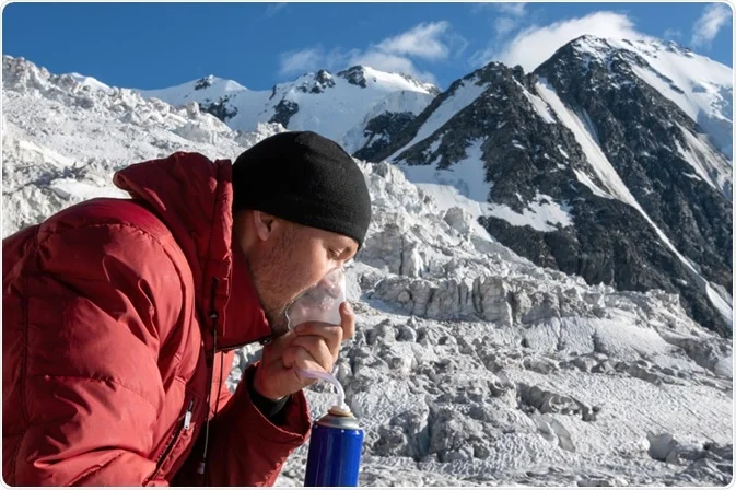
More severe altitude illness, High Altitude Pulmonary Edema (HAPE) and High Altitude Cerebral Edema (HACE), are medical emergencies. HAPE symptoms: extreme breathlessness at rest, persistent cough, pink frothy sputum. HACE symptoms: severe headache unresponsive to painkillers, loss of coordination, confusion, altered consciousness. Both require immediate descent and emergency evacuation.
Prevention Protocol on the Annapurna Circuit
- Follow the itinerary. Our acclimatization schedule, gradual ascent, rest day at Manang, High Camp stop, is built on established altitude medicine protocols endorsed by the HRA.
- Hydrate. 3–4 litres of water daily above 3,000 m. Dehydration worsens all altitude symptoms.
- Never ascend with symptoms. If you have a headache at 9 AM in Manang, you do not leave for High Camp that day. This rule is non-negotiable at Hi Nepal.
- Consider Diamox. Acetazolamide (Diamox) taken 24 hours before altitude gain reduces AMS risk for many trekkers. Discuss with your doctor before the trek, it requires a prescription and is not suitable for everyone (those with sulfa allergies must avoid it).
- Attend the HRA lecture. Free, evidence-based, and potentially life-saving. Every afternoon at 3 PM in Manang.
Hi Nepal’s Safety Protocols
All Hi Nepal guides carry a pulse oximeter and monitor SpO2 readings at Pisang (3,300 m), Manang (3,519 m), Thorong Phedi (4,450 m), High Camp (4,925 m), and the pass (5,416 m). We maintain direct emergency contacts with two helicopter companies operating out of Pokhara and Kathmandu, and can arrange evacuation within 2–4 hours on most days. Our guides hold Wilderness First Responder certification and receive annual altitude medicine refresher training through the HRA.
Closing Thoughts from Our Guide
The Annapurna Circuit Trek from Pokhara is not just a physical journey, it is an immersion in the full breadth of the Himalaya, from the subtropical river valleys where I grew up, to the wind-scoured passes at 5,416 m where prayer flags beat against a sky that seems impossibly close. It spans five climate zones, countless cultures, and one of the most dramatic elevations changes in trekking. It will test you, humble you, and ultimately leave you changed in ways that are difficult to articulate but impossible to forget.
Starting this journey from Pokhara gives it its perfect shape, the comfortable, beautiful lakeside city as your launchpad and your celebration. At Hi Nepal Travels and Treks, our guides, porters, and support staff have dedicated their professional lives to making this journey as safe, authentic, and rewarding as possible. We are not just a service provider, this is our home, and we are sharing it with you.
— Bam Tamang, Senior Trekking Guide, Hi Nepal Travels and Treks
Frequently Asked Questions
How long is the Annapurna Circuit Trek from Pokhara?
The standard Hi Nepal itinerary is 14 days including transport days. Extended versions adding Tilicho Lake or a more relaxed pace take 16–18 days. Total trekking distance is approximately 160–230 km depending on route variants taken.
How do I get from Pokhara to the Annapurna Circuit trailhead?
Hi Nepal provides private jeep transport from your Pokhara hotel to Besisahar (~72 km, 2–3 hours). This is included in our package. The road is paved and well-maintained. Trekking begins on arrival in Besisahar.
What is the cost of the Annapurna Circuit Trek from Pokhara?
Hi Nepal offers the Annapurna Circuit Trek from Pokhara starting at USD 1,500 per person. The final price depends on group size, private vs. shared departure, and optional add-ons. We provide a detailed quote with full cost breakdown, no hidden charges. Contact us directly for your personalised quote.
Is the Annapurna Circuit Trek from Pokhara suitable for beginners?
Yes, for physically fit beginners who train seriously in advance. No technical climbing is required. Hi Nepal’s carefully paced itinerary, acclimatization day at Manang, and experienced guide support make it achievable for motivated first-time trekkers. Start a structured fitness programme 8–10 weeks before departure.
What permits do I need for the Annapurna Circuit?
Two permits: the ACAP Permit (Annapurna Conservation Area Project, ~USD 22) and the TIMS Card (~USD 15 individually, free when booked through a registered agency like Hi Nepal). Both are included in our package and processed by our team before departure.
How hard is crossing Thorong La Pass?
It is the most demanding day of the trek, 7–9 hours with a 500 m ascent at over 5,000 m altitude followed by a 1,600 m descent on steep, loose trail. With proper acclimatization (the Manang rest day and High Camp overnight are essential), an early start, trekking poles, and Hi Nepal’s guide support, the great majority of our trekkers complete it successfully.
What is the best month for the Annapurna Circuit Trek from Pokhara?
October offers the clearest skies and most stable conditions. April adds spectacular rhododendron forests. March, May, September, and November are all excellent alternatives with their own character. Avoid June–August (monsoon) and January–February (potential pass closure).
Do I need travel insurance for the Annapurna Circuit Trek?
Yes, travel insurance covering high-altitude trekking above 5,000 m and emergency helicopter evacuation is mandatory for all Hi Nepal trekkers. A helicopter evacuation from the pass area can cost USD 3,000–5,000+ without insurance. Hi Nepal verifies insurance documents before departure.
Can I do the Annapurna Circuit without a guide?
Independent trekking is legally permitted. However, a certified guide significantly improves altitude safety, emergency response capability, cultural depth, and logistical ease. For trekkers unfamiliar with AMS management or first-time visitors to Nepal, a guide is very strongly recommended. Hi Nepal’s guides are NMA-certified with Wilderness First Responder training.
Can the itinerary include Tilicho Lake or Upper Mustang?
Yes. Tilicho Lake (4,949 m, one of the highest lakes in the world) is a 2-day extension from Manang. Upper Mustang requires an additional restricted area permit (USD 500/10 days) and adds the extraordinary high plateau kingdom beyond Kagbeni. Hi Nepal designs fully customised itineraries for both extensions.
Ready for Your Next Adventure?
Discover more amazing treks and expeditions in Nepal. Let us help you plan your perfect mountain adventure.