The Annapurna Circuit is one of the world’s most celebrated long-distance treks, circling the entire Annapurna Massif through Nepal’s Himalayan heartland. The total Annapurna Circuit Trek distance ranges from 160 km to 230 km (100–145 miles), depending on how much of the motorable road sections you walk versus drive, and whether you add optional side trips such as Tilicho Lake or the Poon Hill extension.
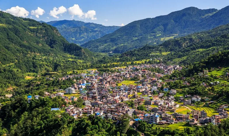
The Annapurna Circuit distance is often debated because the trail is as flexible as the mountains are high. One of Nepal’s most iconic long treks, it offers a horseshoe-shaped journey that transitions from lush tropical jungles to the high-altitude deserts of the Tibetan plateau.
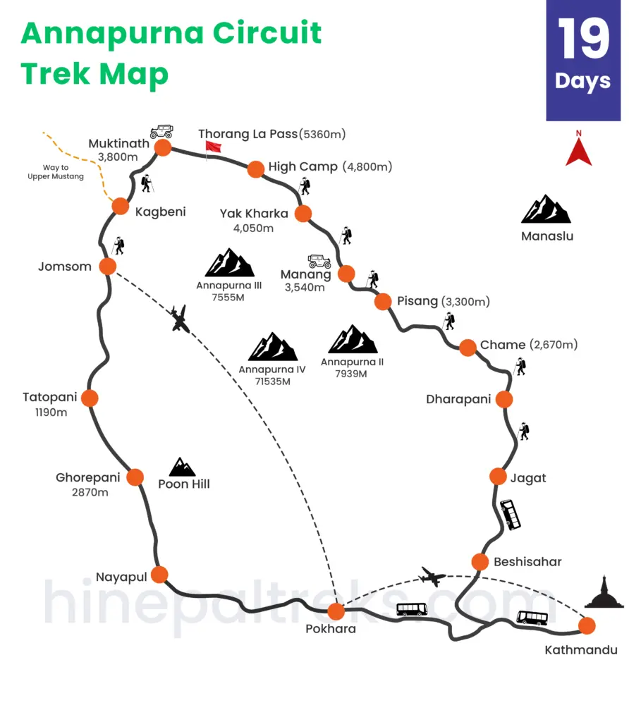
Historically, the full loop distance from Besisahar to Nayapul stretched over 230 km. Today, most trekkers follow a modern standard of roughly 160 km of actual footpath, using jeep transfers to skip the dusty lower road sections while keeping every high-altitude trail intact. This guide gives you a clear, honest, day-by-day breakdown of every kilometer so you can plan with confidence.
Below is a clear daily distance and route breakdown mapped to a standard high-value itinerary, ensuring you know exactly how many kilometers stand between you and the legendary Thorong La Pass.
Annapurna Circuit: Key Facts at a Glance
| Fact | Detail |
|---|---|
| Total Trekking Distance | 160–230 km (100–145 miles) depending on road use & side trips |
| Actual Walking Distance (this itinerary) | ~145–160 km on footpath |
| Duration | 19 days (including Kathmandu days & Poon Hill extension) |
| Highest Point | Thorong La Pass — 5,416m (17,769 ft) |
| Lowest Point | Tatopani — 1,190m (3,904 ft) |
| Average Daily Distance | 8–16 km per trekking day |
| Average Daily Walking Time | 5–7 hours; Summit Day 8–10 hours |
| Best Seasons | Spring (March–May) and Autumn (September–November) |
| Guide Requirement (2026) | Mandatory for all foreign trekkers (Nepal Tourism Board regulation) |
| Compared to Everest Base Camp | Thorong La (5,416m) is slightly higher than EBC (5,380m); more diverse terrain |
Elevation Profile: The Bell Curve of the Himalayas
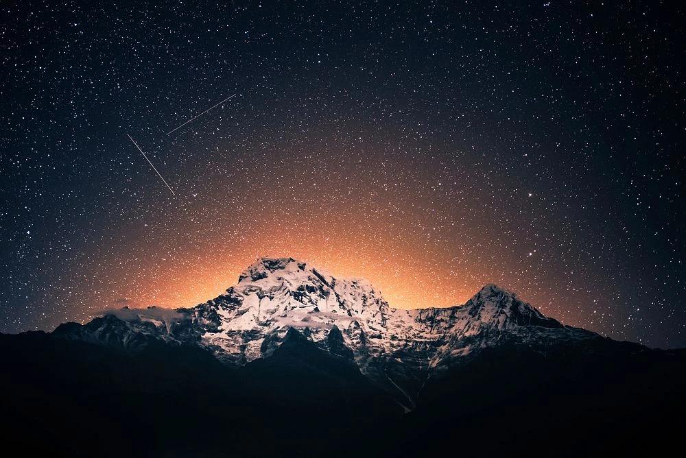
The Annapurna Circuit follows a classic bell-curve elevation profile. You begin in the humid subtropical lowlands around 1,300–1,400m, steadily climb through temperate forests, alpine meadows, and high-altitude desert to the single dramatic peak of Thorong La Pass at 5,416m, then descend rapidly into the Mustang rain shadow and the lush rhododendron forests of the Ghorepani region.
Pro Tip: Because the highest point of the Annapurna Circuit is so significantly higher than the surrounding villages, the day you cross the pass involves a massive 1,000 m ascent and a 1,600 m descent.
The Three Terrain Zones
Lowland Subtropical (Jagat to Chame, 1,340–2,650m): Longer walking days of 14–16 km are manageable thanks to dense oxygen, well-defined trails, and moderate gradients along the Marsyangdi River valley.
Alpine High-Altitude Zone (Manang to Thorong Phedi, 3,500–4,450m): Daily Annapurna Circuit Trek distances intentionally drop to 7–11 km. Above 3,000m, the body operates with significantly less available oxygen, at the Thorong La summit, you breathe roughly 50% less oxygen than at sea level. Every step demands more from your cardiovascular system.
Descending Rain Shadow & Finish (Muktinath to Ghandruk, 3,710–2,012m): The western and southern sides of the circuit plunge through the deepest gorge on Earth (Kali Gandaki) before rising again into the world-famous rhododendron forests around Ghorepani.
The Pass Day in Numbers: On Day 12, you face a 966m ascent from Thorong Phedi to the pass summit, followed by a 1,706m descent to Muktinath, all within roughly 16 km. This asymmetry makes it the most physically and mentally demanding single day of the trek.
Daily Distance Breakdown of Annapurna Circuit Trek
Phase 1 – The Lowland Warm-Up (Days 4–6)
Starting from Jagat (1,340m), these first three trekking days follow the Marsyangdi River upstream through cascading waterfalls, terraced farmland, and traditional Gurung and Manangi settlements. The air is rich and warm, and the daily Annapurna Circuit Trek distances of 14–16 km let your legs adapt gradually.
| Day | Route | Altitude | Distance | Terrain Notes |
|---|---|---|---|---|
| 4 | Jagat → Dharapani | 1,860m | ~15 km | River valley, waterfalls, first villages |
| 5 | Dharapani → Chame | 2,650m | ~16 km | Pine forest; Mt. Manaslu views appear |
| 6 | Chame → Pisang | 3,250m | ~14 km | Dramatic rock faces; alpine meadows begin |
Phase 2 – Into the High Himalayas (Days 7–9)
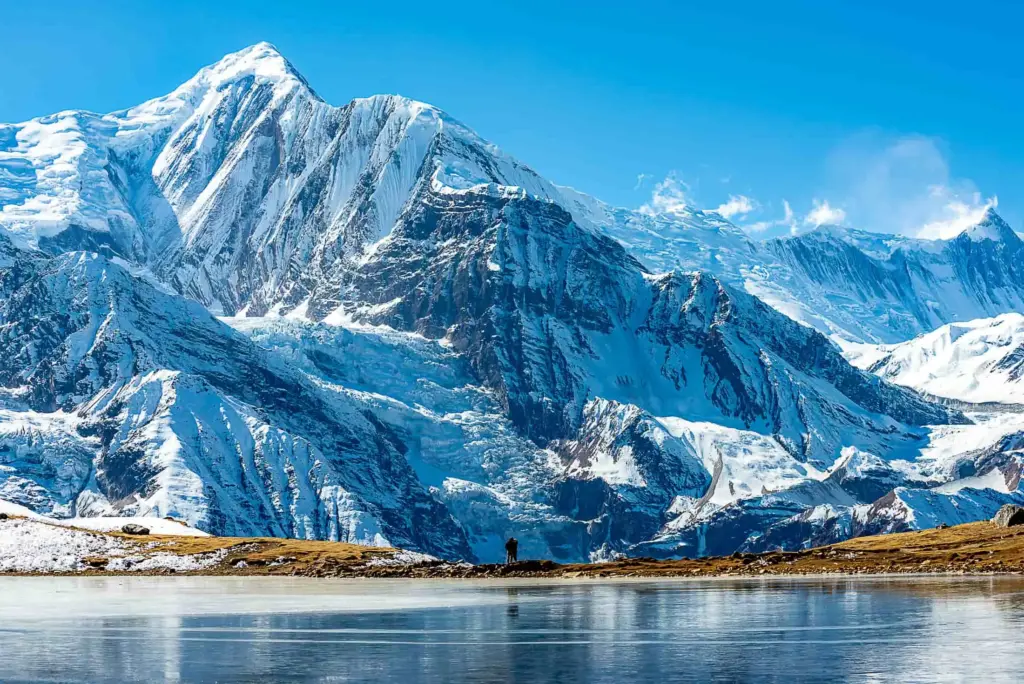
As you enter the Manang Valley, the landscape transforms into high-altitude Tibetan-influenced terrain. Daily Annapurna Circuit Trek distances drop to 9–10 km as elevation gain becomes the primary challenge. Day 7 takes the superior ‘High Trail’ via Ghyaru and Ngawal, adding slight elevation but rewarding you with the most expansive, unobstructed views of the Annapurna range found anywhere on the circuit.
| Day | Route | Altitude | Distance | Terrain Notes |
|---|---|---|---|---|
| 7 | Pisang → Ngawal (High Trail) | 3,660m | ~10 km | Best Annapurna panoramas on the circuit |
| 8 | Ngawal → Manang | 3,518m | ~9 km | Gradual descent; ancient monasteries |
| 9 | Rest Day in Manang | 3,518m | Side trip | Ice Lake hike to 4,600m; ‘climb high, sleep low’ |
Phase 3 – The High-Altitude Push (Days 10–11)
These two short days are the most safety-critical of the entire trek. Moving from Manang to Yak Kharka (10.5 km) and then Thorong Phedi (7 km) adheres strictly to the internationally recommended guideline of gaining no more than 300–500m of sleeping altitude per day above 3,000m. The brevity of these stages is a deliberate medical decision, not a lack of ambition.
| Day | Route | Altitude | Distance | Why This Distance? |
|---|---|---|---|---|
| 10 | Manang → Yak Kharka | 4,020m | ~10.5 km | 502m gain – at safe daily limit for AMS prevention |
| 11 | Yak Kharka → Thorong Phedi | 4,450m | ~7 km | 430m gain – conserves energy for summit day |
Phase 4 – Summit Day & Sacred Descent (Day 12)
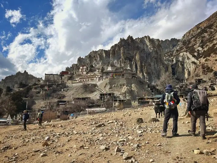
Day 12 is the centerpiece of the entire Annapurna Circuit. Departing Thorong Phedi or High Camp at 4:00 AM, you ascend nearly 1,000 vertical meters through pre-dawn darkness and thin mountain air to the summit of Thorong La Pass (5,416m). The descent of 1,706m to the sacred Hindu and Buddhist pilgrimage site of Muktinath (3,710m) is equally demanding on the knees and concentration.
| Day | Route | Peak Altitude | Distance | Summit Day Facts |
|---|---|---|---|---|
| 12 | Thorong Phedi → Pass → Muktinath | 5,416m | ~16 km | Start 4 AM; 966m ascent + 1,706m descent; 8–10 hrs |
Phase 5 – The Ghorepani Extension (Days 14–16)
Rather than ending in dusty Jomsom, this itinerary transitions into the lush southern slopes of the Annapurna Conservation Area. The Poon Hill extension adds roughly 40–45 km of some of Nepal’s most beautiful forest trekking, culminating in the globally famous sunrise panorama from Poon Hill (3,210m) over the Dhaulagiri and Annapurna ranges.
| Day | Route | Altitude | Distance | Highlights |
|---|---|---|---|---|
| 14 | Tatopani → Ghorepani | 2,860m | ~17 km | Steep rhododendron & oak forest climb |
| 15 | Poon Hill → Tadapani | 3,210m | ~12 km | Iconic Himalayan sunrise; rich forest trail |
| 16 | Tadapani → Ghandruk | 2,012m | ~7 km | Traditional Gurung village; Annapurna South views |
Key Facts Before the Route Breakdown
To help you prepare, here are the core Annapurna trek facts that define the experience.
Total Annapurna Circuit Trek Distance & Duration
- Total Distance: Typically 160–230 km (100–145 miles). The exact length depends on whether you utilize jeep transport for road sections or add side trips like Tilicho Lake.
- Itinerary Length: Most HI Nepal Travels & Treks packages span 15–20 days. This includes travel from Kathmandu, mandatory acclimatization days, and a buffer for weather.
The Peak of the Journey
- Highest Point of the Annapurna Circuit: The legendary Thorong La Pass at 5,416 m (17,769 ft).
- Daily Gain: Above 3,000 m, the goal is to increase your sleeping altitude by no more than 300–500 m per day to prevent altitude sickness.
Complete 19-Day Day-by-Day Itinerary
The table below is the master reference for the full circuit. All trekking distances reflect footpath kilometers; road sections covered by jeep are marked as ‘Drive.’
| Day | Route | Altitude | Distance | Key Highlights |
|---|---|---|---|---|
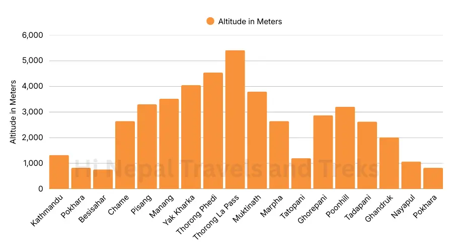
| 01 | Arrive Kathmandu | 1,300m | 0 km | Airport pickup; Thamel welcome dinner |
| 02 | Kathmandu Sightseeing & Trek Prep | 1,300m | 0 km | UNESCO Heritage sites; pre-trek briefing & gear check |
| 03 | Drive Kathmandu → Jagat | 1,340m | Drive | Scenic 8–10 hr drive via Besisahar along Marsyangdi River |
| 04 | Trek to Dharapani | 1,860m | ~15 km | Lush waterfalls, terraced fields, Marsyangdi River trail |
| 05 | Trek to Chame | 2,650m | ~16 km | Pine forests, Bagarchhap & Timang villages, Mt. Manaslu views |
| 06 | Trek to Pisang | 3,250m | ~14 km | Dramatic alpine scenery; panoramic Himalayan vistas begin |
| 07 | Trek to Ngawal (High Trail via Ghyaru) | 3,660m | ~10 km | Best panoramic views of entire Annapurna massif |
| 08 | Trek to Manang | 3,518m | ~9 km | Gradual descent; ancient monasteries; cultural heart of circuit |
| 09 | Rest & Acclimatize in Manang | 3,518m | Side trip | Hike to Ice Lake (4,600m) or Milarepa Cave; ‘climb high, sleep low’ |
| 10 | Trek to Yak Kharka | 4,020m | ~10.5 km | Open alpine pastures; Blue Sheep sightings; expanding panoramas |
| 11 | Trek to Thorong Phedi | 4,450m | ~7 km | Steady, slow ascent; final preparation for pass crossing |
| 12 | Cross Thorong La Pass → Muktinath | 5,416m | ~16 km | Summit day: world-class pass, sacred Muktinath temples |
| 13 | Drive to Tatopani | 1,190m | Drive | Kali Gandaki Gorge; natural hot spring recovery |
| 14 | Trek to Ghorepani | 2,860m | ~17 km | World-famous rhododendron & oak forest; steep but rewarding |
| 15 | Poon Hill Sunrise → Trek to Tadapani | 3,210m | ~12 km | Iconic sunrise over Dhaulagiri & Annapurna ranges |
| 16 | Trek to Ghandruk | 2,012m | ~7 km | Traditional Gurung village; Annapurna South close-up views |
| 17 | Drive to Pokhara | 820m | Drive | Lakeside relaxation; celebration dinner |
| 18 | Return to Kathmandu | 1,300m | Drive | 6–7 hr drive or optional flight; farewell cultural dinner |
| 19 | Final Departure | 1,300m | 0 km | Airport transfer; lifetime of memories |
How Itinerary Choices Affect Total Distance of the Annapurna Circuit
One of the Annapurna Circuit’s greatest strengths is its flexibility. The total distance of Annapurna Circuit Trek you walk is not fixed, it scales with the choices you make at the planning stage.
Route Variants by Total Distance
| Route Option | Distance | Duration | Best For |
|---|---|---|---|
| Full Classic (Besisahar → Nayapul + Poon Hill) | ~230 km | 21–22 days | Purists who want every footpath kilometer |
| Modern Standard (jeep lower section, Poon Hill finish) | ~160 km | 18–19 days | Best balance of scenery, safety & experience |
| Compact Route (start at Chame, fly Jomsom) | ~100 km | 12–14 days | Experienced trekkers with limited time |
| +Tilicho Lake Side Trip (from Manang) | +35–40 km | +3 days | World’s highest glacial lake at 4,919m |
| +Ice Lake / Kicho Tal (acclimatization hike) | +14–16 km | +1 day | Excellent acclimatization from Manang |
Road Impact: The Kali Gandaki road from Muktinath to Jomsom is now fully paved. The 5-hour walk is now often replaced with a 20-minute jeep ride, saving knees for the final Ghorepani section. We recommend this swap for most trekkers.
Why Altitude Changes How Distance Feels?
A kilometer at sea level and a kilometer at 5,000m are not the same physical challenge. This is the most commonly underestimated aspect of the Annapurna Circuit for first-time high-altitude trekkers.
The Science of Altitude Performance
- Reduced aerobic capacity: Above 4,000m, even highly fit trekkers experience a 20–30% drop in sustainable walking pace.
- Terrain multiplication: The loose scree, glacial moraine, and occasional snow above Manang demand constant micro-adjustments that consume significantly more energy than forest or river paths.
- The 50% oxygen threshold: At Thorong La Pass (5,416m), atmospheric oxygen is approximately half that of sea level. Your heart rate at rest will be noticeably elevated.
- Psychological fatigue: Pre-dawn starts, cold temperatures, and the mental weight of altitude can make 16 km on summit day feel three times longer than 16 km at lower elevations.
Average Daily Distances & Walking Tips
The Annapurna Circuit is a journey of endurance, not a race. While the total Annapurna Circuit Trek distance spans approximately 160–230 km depending on road use, your daily experience is defined by the changing altitude and terrain. On average, you will cover 8–16 km per day, with walking times ranging from 4 to 9 hours.
Understanding the Daily Grind
- Lower Elevations (Jagat to Chame): Expect longer distances of 14–16 km. The air is thick with oxygen, and the trails are well-defined, allowing for a brisker pace.
- The Alpine Zone (Manang to Thorong Phedi): Distances drop to 7–10 km. While the kilometers are fewer, the thinning air makes every step feel twice as heavy. These are critical “slow-and-steady” days.
- The Big Pass (Thorong La Day): This is your longest and toughest day, covering roughly 16 km. You’ll start before dawn (usually 4:00 AM) to beat the high winds at the summit, totaling 8–10 hours of movement.
Pro Tips for a Successful Trek
To conquer the circuit comfortably, keep these “Golden Rules” in mind:
- Find Your “Himalayan Pace”: Walk at a speed where you can still hold a full conversation without gasping for breath. If you’re too breathless to talk, you’re moving too fast for the altitude.
- Hydration is Your Secret Weapon: Aim to drink 3–4 liters of water daily. Dehydration mimics and worsens altitude sickness symptoms, so keep sipping even if you don’t feel thirsty.
- The “Climb High, Sleep Low” Strategy: On acclimatization days in Manang, take a short afternoon hike to a higher viewpoint (like Gangapurna Lake) before returning to the village to sleep. This “teaches” your blood how to carry more oxygen.
- Master the Descent: The trek doesn’t end at the pass. The 1,600m descent to Muktinath is brutal on the knees. Use trekking poles and take frequent short breaks to save your joints for the final days.
Altitude & Terrain Impact on Distance Perception
On the Annapurna Circuit, a kilometer at 1,300m is not the same as a kilometer at 5,000m. As you ascend into the “Thin Air” zone above 4,000 meters, your body’s ability to process oxygen drops significantly, at the Thorong La Pass, you are breathing roughly 50% less oxygen than at sea level. This physiological shift fundamentally changes how you perceive distance and difficulty.
The “Altitude Stretch” Effect
- Reduced Aerobic Power: Above 4,000m, even the fittest hikers will experience a decline in pace by 20–30%. A trail that looks like a short 2-hour stroll on a map can easily take 4 hours because your heart and lungs are working double-time just to maintain a steady step.
- Terrain as a Time-Multiplier: The trails around Manang and the Thorong La Pass aren’t just high; they are rugged. You’ll encounter loose scree, slippery glacial moraine, and occasionally deep snow. These surfaces require constant micro-adjustments in your footing, which consumes more energy than walking on the paved or forest paths found earlier in the trek.
- The Psychology of the Pass: On Day 12 (Thorong La), the distance is roughly 16 km. However, the steep 1,000m ascent followed by a 1,600m descent makes this feel like the longest day of your life. Every step requires mental resilience as much as physical strength.
Why the Itinerary Shortens Near the Top?
You may notice that your daily Annapurna Circuit distances drop significantly as you approach the pass. This is a deliberate safety feature of the Hi Nepal Travels & Treks itinerary:
- Strategic Micro-Distances: Moving from Yak Kharka to Thorong Phedi covers only about 7 km. While this seems short, the 400m+ elevation gain is the maximum your body should safely handle in a single day at that altitude to prevent Acute Mountain Sickness (AMS).
- Cultural Village Stops: The Annapurna Circuit is unique because it connects ancient trade routes. These villages are perfectly spaced to ensure you aren’t forced to walk too far between safe havens, allowing you to rest in comfortable tea houses before the air gets too thin.
Expert Trekking Tips for Managing Distance & Altitude
The Himalayan Pace
Walk at a speed at which you can hold a full conversation without gasping. If talking becomes difficult, slow down immediately. Speed is irrelevant above 4,000m, steady forward movement is the only goal.
Hydration Strategy
Target 3–4 liters of water per day throughout the trek. Dehydration is both a cause and an amplifier of Acute Mountain Sickness (AMS). Carry a reusable bottle and use purification tablets or filters for stream water at higher elevations.
Climb High, Sleep Low
On the rest day in Manang (Day 9), hike up to the Ice Lake (4,600m) and return to sleep at 3,518m. This ‘trains’ your red blood cells to carry more oxygen, making the high-altitude days that follow measurably safer and more comfortable.
Protect Your Knees on the Descent
The 1,706m descent from Thorong La to Muktinath is the most knee-intensive section of the circuit. Use trekking poles with weight shifted through the handles, take short breaks every 30–40 minutes, and step down with your stronger leg leading on steep sections.
The 4:00 AM Summit Start
Departing Thorong Phedi before dawn is non-negotiable. Afternoon winds at the pass frequently reach dangerous speeds. Starting early ensures you cross the summit before 11:00 AM when conditions are calmest and safest.
Ready to Plan Your Annapurna Circuit Trek?
The Annapurna Circuit is more than a distance to be covered, it is a journey through some of the most geographically and culturally diverse terrain on the planet. From the subtropical riverbanks of the Marsyangdi to the wind-scoured prayer flags of Thorong La, every kilometer tells a different story.
Knowing the exact distances, elevation changes, and daily targets before you arrive means you can spend your time on the trail present in the experience, rather than wondering what lies ahead. That is the purpose of this guide.
Hi Nepal Travels & Treks | +977 9856035091 | info@hinepaltreks.com
Licensed by the Nepal Tourism Board. Members of the Trekking Agencies Association of Nepal (TAAN). Guiding the Annapurna Circuit since 2005.
FAQ(Annapurna Circuit Trek Distance & Planning)
-
How many km is the Annapurna Circuit Trek?
The total Annapurna Circuit Trek distance ranges from 160 km to 230 km (100–145 miles). The figure depends on road use and optional side trips. The Hi Nepal Treks 19-day itinerary covers approximately 145–160 km of actual footpath, avoiding the dusty motorable road sections entirely.
-
What is the distance on the Thorong La Pass crossing day?
Thorong La Summit Day covers approximately 16 km, beginning at Thorong Phedi (4,450m) and finishing at Muktinath (3,710m) after crossing the 5,416m pass. While 16 km is not unusual in distance, the nearly 1,000m ascent and 1,700m descent at extreme altitude makes it by far the most demanding day of the trek, typically requiring 8–10 hours.
-
What is the average daily walking distance on the circuit?
Most trekkers cover 10–16 km per day at lower elevations and 7–11 km per day above 3,500m. The deliberate reduction at high altitude is not about ease, it is a critical acclimatization strategy to prevent Acute Mountain Sickness.
-
Is the Annapurna Circuit harder than Everest Base Camp?
Both treks are comparably challenging for different reasons. The Annapurna Circuit covers more total distance and crosses a higher pass, Thorong La at 5,416m versus Everest Base Camp at 5,380m. The Annapurna Circuit also demands more sustained endurance across varied terrain, while EBC involves a more consistent out-and-back gradient. The circuit is generally considered more diverse in landscape and culture.
-
Can I shorten the Annapurna Circuit trek?
Yes. Taking a jeep to Chame or Manang can reduce the trek to 12–14 days. However, skipping the lower acclimatization stages significantly increases the risk of AMS. We recommend a minimum of 18–19 days for first-time high-altitude trekkers.
-
How many hours do you walk each day?
On standard trekking days you walk 5–7 hours. The Thorong La summit day is the exception, requiring 8–10 hours of movement, starting around 4:00 AM to clear the pass before afternoon winds intensify.
-
Is a licensed guide required for the Annapurna Circuit in 2026?
Yes. The Nepal Tourism Board requires all foreign trekkers to hire a licensed, registered guide for high-altitude treks in the Annapurna region. This regulation, introduced to improve trekker safety and support local livelihoods, is enforced at permit checkpoints along the trail.
-
What is the best time of year to trek the Annapurna Circuit?
The two peak seasons are Spring (March–May) and Autumn (September–November). These windows offer the clearest skies, most stable trail conditions, and the highest probability of a snow-free Thorong La Pass. Experienced trekkers sometimes choose early December for quieter trails and crisp visibility, though the pass requires careful monitoring.
-
How much elevation gain is safe per day above 3,000m?
International wilderness medicine guidelines recommend a maximum sleeping altitude gain of 300–500m per day above 3,000m. Every stage of this 19-day itinerary is designed to stay within this range. Days 10 and 11 are the most carefully calibrated, gaining 502m and 430m respectively to place you in the safest possible condition for the pass crossing.