
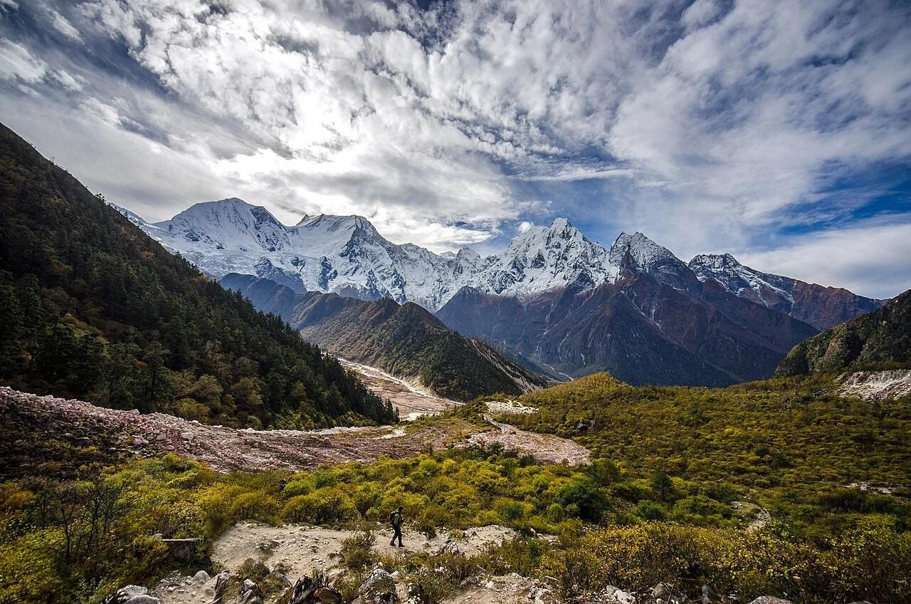
Planning the Manaslu Circuit Trek can be confusing when maps show different starting points, distances, elevations, and Larkya La Pass heights. Recent trail changes near Namrung make it even more important to know which route to follow in 2026.
The Manaslu Circuit is open again after the September 2026 flood damage near Namrung. The classic counter-clockwise route runs from Machha Khola to Dharapani, crossing Larkya La Pass at around 5,106 m. However, local trail conditions can still change due to weather, landslides, or temporary repairs.
In this guide, you’ll find the Manaslu Circuit map, complete route, key villages, elevations, distances, Larkya La Pass, and the latest Namrung trail update.
Manaslu Circuit Trek Route at a Glance
The route follows the Budhi Gandaki Valley from Machha Khola to Samagaon, crosses Larkya La, then descends through Bimthang to Dharapani.
| Route | Details |
|---|---|
| Route | Machha Khola → Dharapani |
| Highest point | Larkya La, 5,106 m |
| Typical trip length | 12 to 16 days |
| Direction | Counter-clockwise |
| Main valley | Budhi Gandaki |
| Major pass | Larkya La |
| Main acclimatization stop | Samagaon |
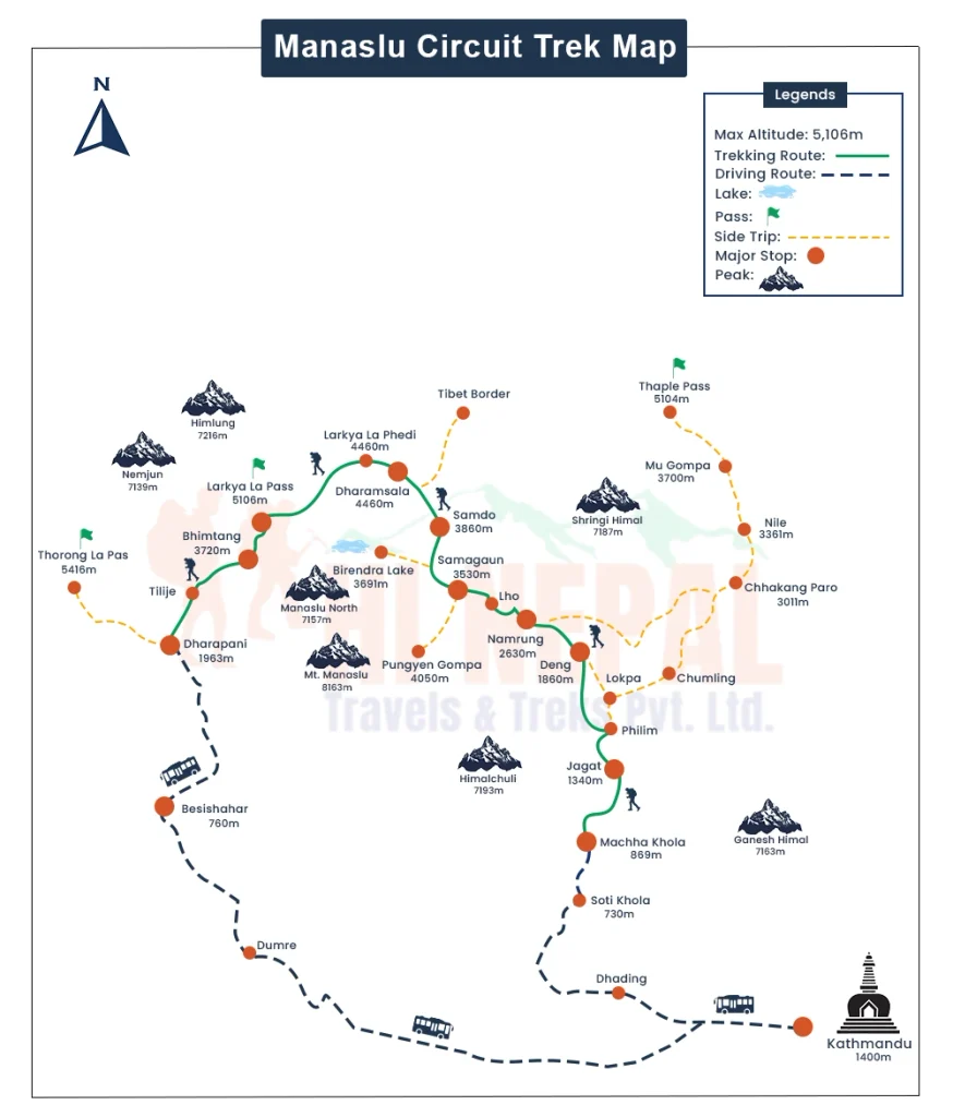
Machha Khola → Jagat → Deng → Namrung → Lho → Shyala → Samagaon → Samdo → Dharamsala → Larkya La → Bimthang → Dharapani
What Has Changed on the Manaslu Route in 2026?
Older Manaslu maps often show Soti Khola as the starting point, while many current itineraries continue by road to Machha Khola (around 870 m) before the walking section begins. The drive from Kathmandu to Machha Khola generally takes 7–8 hours, depending on road conditions.
The main route remains unchanged: Machha Khola → Jagat → Deng → Namrung → Samagaon → Samdo → Dharamsala → Larkya La → Bimthang → Dharapani.
September 2026 Flood Damage Near Namrung
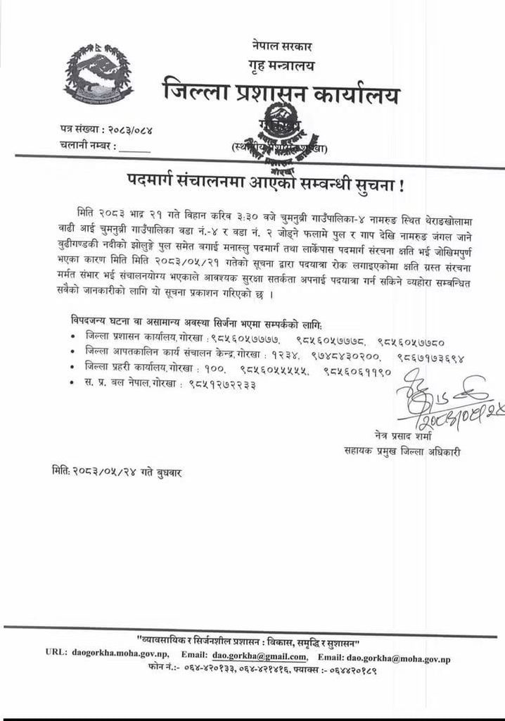
A flash flood on September 6, 2026, damaged bridges and trail infrastructure around Namrung in the Manaslu region. The disruption temporarily affected access along the main circuit, including the route toward Samagaon and Larkya La.
Local residents and authorities responded by creating alternative crossings and a bypass so trekkers could move through the affected section again.
The Nepal Tourism Board reported on September 11 that the damaged structures had been restored to a condition suitable for trekking and that the earlier restriction had been lifted.
However, the situation is not identical to the pre-flood route. A late-September field update reported that the Namrung section was still using a community-built bypass and temporary wooden bridges, rather than the original permanent suspension bridge.
Planning tip: Use older maps to understand the overall route, but follow your guide’s instructions for current trail conditions rather than relying on pre-flood GPS tracks.
Manaslu Circuit Trek Route: Day-by-Day
The standard walking itinerary covers 9 days, including an acclimatization day in Samagaon. Distances, walking times, and elevations vary by itinerary and trail conditions.
The exact distances, walking hours, and village elevations can vary between itineraries. The table below gives a practical overview of the standard route.
| Day | Route | Altitude (start → end) | Walking time |
|---|---|---|---|
| 1 | Machha Khola → Jagat | 870 m → 1,340 m | 6–7 hrs |
| 2 | Jagat → Deng | 1,340 m → 1,860 m | 6–7 hrs |
| 3 | Deng → Namrung | 1,860 m → 2,630 m | 6–7 hrs |
| 4 | Namrung → Lho → Shyala → Samagaon | 2,630 m → 3,530 m | 6–8 hrs |
| 5 | Acclimatization in Samagaon | 3,530 m | 4–6 hrs, optional hike |
| 6 | Samagaon → Samdo | 3,530 m → 3,875 m | 3–4 hrs |
| 7 | Samdo → Dharamsala | 3,875 m → 4,460 m | 4–5 hrs |
| 8 | Dharamsala → Larkya La → Bimthang | 4,460 m → 5,106 m → 3,720 m | 8–11 hrs |
| 9 | Bimthang → Dharapani | 3,720 m → 1,860 m | 7–8 hrs |
Elevations and walking times are approximate. Different maps and itineraries may vary by 30–100 m in village elevations, while weather, trail conditions, and individual pace can significantly affect walking time.
Machha Khola to Namrung
Machha Khola → Jagat → Deng → Namrung
The trail follows the Budhi Gandaki Valley through suspension bridges, waterfalls, stone stairways, forests, and traditional mountain villages. The repeated climbs and descents can make these lower-altitude days more demanding than the elevation gain suggests.
Route note: Jagat is an important permit checkpoint. Ghap may also appear on maps between Deng and Namrung, although it is not always an overnight stop. Around Namrung, follow the current local trail rather than an older GPS track.
Namrung to Samagaon
Namrung → Lho → Shyala → Samagaon
The landscape opens as you climb toward the upper Budhi Gandaki Valley, with terraced fields, monasteries, mani walls, and clearer mountain views. Lho and Shyala are highlights before reaching Samagaon at 3,530 m.
The route gains roughly 900 m, so maintaining a steady pace is important as the altitude increases.
Acclimatization in Samagaon
Samagaon → Optional acclimatization hike → Samagaon
Most itineraries include a second night at 3,530 m to allow acclimatization before the route climbs toward Samdo, Dharamsala, and Larkya La.
Depending on conditions, trekkers can take an optional hike toward Manaslu Base Camp or Birendra Lake before returning to Samagaon.
Samagaon to Dharamsala
Samagaon → Samdo → Dharamsala (Larkya Phedi)
The route becomes increasingly alpine as trees thin out and the valley turns wider and more rugged. Samdo (3,875 m) is the last major village before Dharamsala, or Larkya Phedi (4,460 m).
Dharamsala is a basic high-altitude stop, so use the evening to eat, hydrate, prepare your gear, and rest before the pass crossing.
Dharamsala to Bimthang via Larkya La
Dharamsala → Larkya La → Bimthang
The Larkya La crossing is the longest and highest day of the Manaslu Circuit. Trekkers commonly start in the early morning, often around 3–4 a.m., depending on weather, season, and their guide’s plan.
The climb from Dharamsala to Larkya La (approximately 5,106 m) is gradual but demanding because of the altitude, cold, and potentially snowy or icy conditions. At the top, prayer flags mark the pass, with views toward peaks including Himlung Himal, Cheo Himal, and Annapurna II.
The route becomes increasingly alpine as trees thin out and the valley turns wider and more rugged. Samdo (3,875 m) is the last major village before Dharamsala, or Larkya Phedi (4,460 m).
Dharamsala is a basic high-altitude stop, so use the evening to eat, hydrate, prepare your gear, and rest before the pass crossing.
- Walking time: 8–11 hours
- Highest point: Approximately 5,106 m
- Weather: Snow, strong winds, or poor visibility can affect the crossing and may require changes to the itinerary
For a closer look at the pass, see our Larkya La Pass guide.
Bimthang to Dharapani
Bimthang → Dharapani
After crossing Larkya La, the route begins a long descent into greener terrain. From Bimthang, the trail descends through pine and rhododendron forests toward Dharapani (around 1,860 m), marking the end of the classic Manaslu Circuit.
Reaching Dharapani at around 1,860 m marks the end of the classic Manaslu Circuit. From here, trekkers can continue by road toward Besisahar and then Pokhara or Kathmandu. Some also connect the route with the Annapurna Circuit for a longer Himalayan journey.
Manaslu Circuit Trek Elevation and Acclimatization
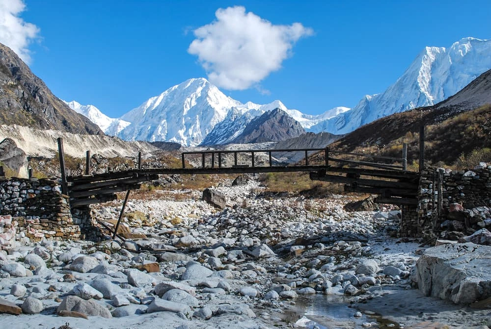
The Manaslu Circuit rises from 870 m at Machha Khola to approximately 5,106 m at Larkya La. Altitude becomes a greater concern above 3,000 m, making gradual ascent and acclimatization important.
Why Samagaon Is the Key Acclimatization Stop
Samagaon (3,530 m) is the main acclimatization stop before the route climbs above 4,000 m. Most itineraries include two nights here, with an optional higher-elevation hike before returning to the village.
Watch for symptoms such as headache, nausea, dizziness, unusual tiredness, or loss of appetite. If symptoms worsen, tell your guide and consider resting or descending rather than continuing higher.
Why Larkya La Is the Most Challenging Day
The Dharamsala–Larkya La–Bimthang stage is usually the hardest day, combining high altitude, cold temperatures, an early start, a long ascent, and a steep descent.
Starting around 3–4 a.m., trekkers climb from 4,460 m to approximately 5,106 m before descending to Bimthang. Snow, strong winds, or poor visibility can affect the crossing, so follow your guide’s advice and be prepared for itinerary changes.
Walking time: 8–11 hours
Highest point: Approximately 5,106 m
Important: Altitude sickness can become serious. Follow your guide’s advice, and if symptoms are severe or worsening, descending to a lower elevation is generally more important than continuing the trek.
Side Trips and Route Variations
The main circuit is complete on its own. If you have extra days, a few side trips are worth considering, depending on your time, the weather, and how you feel at altitude.
Tsum Valley Extension
The Tsum Valley branches off before Namrung and adds several days. It offers Tibetan Buddhist culture and monasteries but requires an additional restricted-area permit.
You can combine it with the circuit in our Manaslu and Tsum Valley trek or walk it on its own as the Tsum Valley trek.
Pungyen Gompa
Pungyen Gompa is a moderate hike from Samagaon with mountain views and a quieter alternative to Manaslu Base Camp.
Manaslu Base Camp and Birendra Lake
Manaslu Base Camp is the longer, higher option, while Birendra Lake is a shorter hike from Samagaon. Your guide can recommend one based on conditions and acclimatization.
How Many Days Do You Need for the Manaslu Circuit?
Most complete Manaslu Circuit itineraries take 12–16 days, including transportation, acclimatization, and buffer days.
Your ideal itinerary depends on how much buffer you want:
- 12–13 days: A shorter itinerary with limited flexibility
- 14 days: A comfortable option for most trekkers
- 15–16+ days: More flexibility for weather, road delays, or optional side trips
If you have fixed international or domestic flights, consider keeping at least one spare day after the trek. Road conditions and mountain weather can change quickly, and having a buffer can prevent a small delay from affecting your flight plans.
How to Plan Your Manaslu Circuit Trek
Before departure, make sure you have the route, permits, insurance, and current trail conditions covered.
- Check trail conditions: Confirm the latest Namrung trail and Machha Khola road conditions with your operator.
- Keep an offline map: Download the route before departure because mobile coverage can be limited.
- Arrange permits and guide: Manaslu is a restricted trekking area, so confirm current guide, group, and permit requirements.
- Check insurance: Make sure your policy covers high-altitude trekking and emergency evacuation, including helicopter rescue if required.
- Choose the right season: Spring and autumn generally offer better conditions, while monsoon can bring rain, landslides, and road disruptions.
See our guide to the best time to trek the Manaslu Circuit for a seasonal breakdown.
Ready to Plan Your Manaslu Circuit Trek?
The Manaslu Circuit is best approached with a clear itinerary and some flexibility. The classic route remains the same, Machha Khola to Dharapani via Larkya La, but road access and individual trail sections can change with weather, landslides, and local conditions.
If you prefer to trek with an experienced local team, Hi Nepal Travels & Treks offers a guided 14-day Manaslu Circuit Trek, including permits, a licensed guide, teahouse accommodation, and transportation.
Whichever itinerary you choose, confirm the road access, Namrung trail conditions, permits, and weather with your trekking operator before departure.
Frequently Asked Questions
-
Where does the Manaslu Circuit Trek start?
The trek usually starts at Machha Khola, after driving from Kathmandu. Older itineraries may show Soti Khola as the starting point.
-
Where does the Manaslu Circuit Trek end?
The classic route ends at Dharapani, where trekkers can continue by road toward Besisahar, Pokhara, or Kathmandu.
-
How long does the Manaslu Circuit Trek take?
The standard trekking itinerary takes about 9 days, while complete trips usually take 12–16 days including transportation and buffer days.
-
How high is Larkya La Pass?
Larkya La Pass is approximately 5,106 m high, making it the highest point of the standard Manaslu Circuit route.
-
What is the best month for the Manaslu Circuit Trek?
October and November generally offer excellent conditions, followed by April and May, with clearer weather and more stable trekking conditions.
-
Is the Manaslu Circuit Trek open in 2026?
The route reopened after September 2026 flood damage near Namrung, but temporary crossings may remain. Confirm current conditions before departure.
-
Is a guide mandatory for the Manaslu Circuit?
Yes. Trekkers must use a licensed guide through a registered trekking agency because Manaslu is a restricted trekking area.
-
What permits are required for the Manaslu Circuit?
Trekkers generally need a Manaslu Restricted Area Permit, MCAP permit, and ACAP permit. Permit requirements and fees can change, so confirm before departure.
-
How difficult is the Manaslu Circuit Trek?
The trek is moderate to challenging, with long walking days, steep sections, remote terrain, and high altitude, especially around Larkya La.
-
How many hours do you walk each day?
Most trekking days involve around 3–8 hours of walking, while the Larkya La crossing can take approximately 8–11 hours.
-
Do you need an acclimatization day on the Manaslu Circuit?
Yes. Most itineraries include an acclimatization day at Samagaon, usually with an optional hike to a higher elevation.
-
What is the highest overnight stop on the Manaslu Circuit?
Dharamsala, around 4,460 m, is typically the highest overnight stop before crossing Larkya La Pass.
-
Can beginners do the Manaslu Circuit Trek?
Fit beginners with proper preparation can attempt it, but the altitude, long days, and remote conditions make previous trekking experience beneficial.
-
Can you do the Manaslu Circuit without a guide?
No. A licensed guide arranged through a registered agency is required for the Manaslu Circuit under current restricted-area trekking rules.
-
What happens if the weather changes during the trek?
Your guide may adjust the itinerary, start time, or route depending on snow, rain, wind, landslides, road conditions, or visibility.
-
Is the Manaslu Circuit connected to the Annapurna Circuit?
Yes. The Manaslu Circuit finishes at Dharapani, which is also part of the Annapurna Circuit route, allowing trekkers to combine both.
-
Is the Manaslu Circuit crowded?
It is generally quieter than the Everest and Annapurna routes, although popular sections and peak trekking seasons can still be busy.
-
What is the hardest day of the Manaslu Circuit?
The Dharamsala–Larkya La–Bimthang day is usually the hardest because of altitude, early starts, long hours, and a steep descent.
-
Can you trek the Manaslu Circuit in monsoon?
It is possible, but monsoon rain can bring mud, landslides, swollen rivers, and road disruptions, making conditions less predictable.